The Sea Surface Temperature (SST) project of the European Space Agency (ESA) Climate Change Initiative (CCI) Programme aims to make climate data records for SST longer, more stable and more accurate, providing data users with different forms of data and documentation.
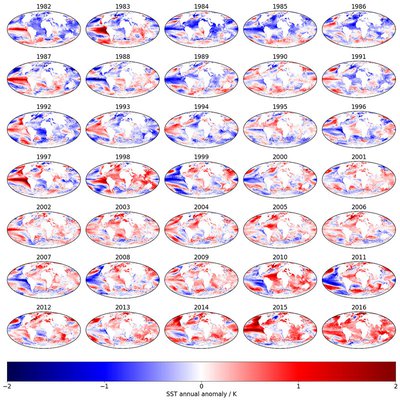
The project team is working on the following aspects of SST:
- Making our climate data record for SST longer, more stable and more accurate
- Providing our data users with the different forms of data and documentation they need
- Sustaining and engineering the software needed to create new version of the SST record
- Innovation in the algorithms we use to achieve improvements in the SST record
The latest version of our climate data record for SST is version 2, which goes back to 1981. We are now within “CCI+” working on version 3, which will particularly improve the data record in the 1980s and 1990s.
Our unique climate data record of SST enables climate model testing, climate model development, and historical NWP re-analyses. We are always willing to work with users on making the most of the data set and understanding its strengths and weakness for their application. You can contact us via Chris Merchant, Science Leader, University of Reading.
Access the full suite of ESA Climate Change Initiative data products via our dedicate Open Data Portal, including those generated by the CCI Sea Surface Temperature project.
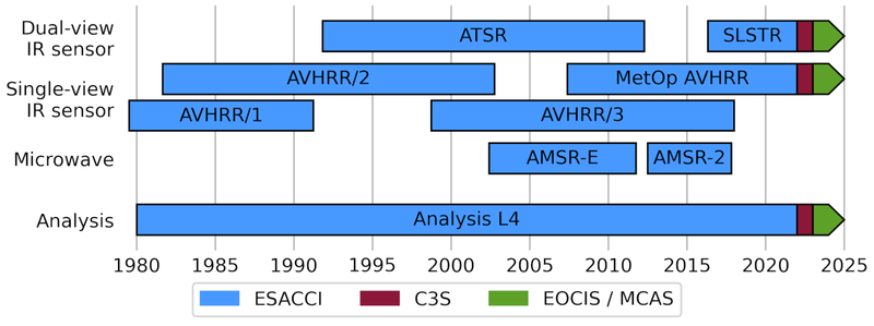
The SST-CCI Climate Data Record (CDR) provides global SST in the period 1980 though 2021 derived from three series of thermal infra-red sensors: the Advanced Very High Resolution Radiometers (AVHRRs), the Along-Track Scanning Radiometers (ATSRs), and the Sea and Land Surface Temperature Radiometers (SLSTRs); and two microwave sensors: the Advanced Microwave Scanning Radiometers (AMSR). The data have been extended since 2022 in the form of an Interim CDR (ICDR) providing an ongoing extension at short delay (approximately 2 weeks behind present). The ICDR was funded by the Copernicus Climate Change Service (C3S) for 2022 and is now funded by the UK Earth Observation Climate Information Service (EOCIS) and UK Marine and Climate Advisory Service (UKMCAS) for 2023 onwards.
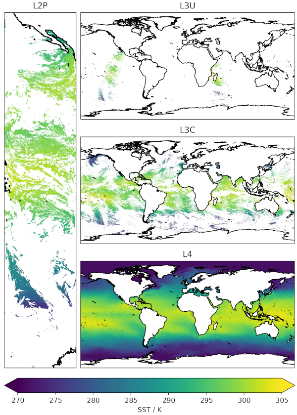
The following data products are available: single-sensor products at their native resolution (Level 2P), single-sensor products remapped to a 0.05° regular latitude-longitude grid (Level 3U), single-sensor products collated into daily files (Level 3C), and a daily gap-free product which combines data from all sensors (Level 4). Data from the infra-red sensors are provided in all three single-sensor levels (Level 2P, Level 3U, and Level 3C), while the microwave AMSR products are only available at level 2P as the native resolution of the AMSR sensors is lower than the 0.05° grid used for Level 3.
Licence
SST CCI data are licensed under the Creative Commons Attribution 4.0 International licence (CC-BY 4.0). This allows the data to be used by any user for any purpose, under the condition that the data are correctly attributed. Users of the data should quote the correct name and version for the dataset in use (as listed in the data pages), and cite the peer-reviewed article describing the Climate Data Record:
Embury, O., Merchant, C.J., Good, S.A., Rayner, N.A., Høyer, J.L., Atkinson, C., Block, T., Alerskans, E., Pearson, K.J., Worsfold, M., McCarroll, N., Donlon, C., (2024). Satellite-based time-series of sea-surface temperature since 1980 for climate applications. Sci Data 11, 326. doi: https://doi.org/10.1038/s41597-024-03147-w
Current Products
Most users want the Level 4 SST CCI analysis product which combines observations from all sensors to produce a global, gridded, gap-free estimate of daily mean SST. However, the gap-filling interpolation does degrade feature resolution, which varies with location, but is typically coarser than 15 km (compared to the grid resolution of 0.05°).
Data may be downloaded from the CEDA archive at ESA SST CCI CDRv3 collection. Or specific datasets from:
- ESA SST CCI Analysis v3.0 - includes ongoing ICDR extension
- ESA SST CCI Climatology v3.0
- ESA SST CCI AMSR L2P v3.0
- ESA SST CCI AVHRR L2P v3.0
- ESA SST CCI AVHRR L3U v3.0
- ESA SST CCI AVHRR L3C v3.0 - includes ongoing ICDR extension
- ESA SST CCI ATSR L2P v2.1
- ESA SST CCI ATSR L3U v2.1
- ESA SST CCI ATSR L3C v2.1
- ESA SST CCI SLSTR L2P v3.0
- ESA SST CCI SLSTR L3U v3.0
- ESA SST CCI SLSTR L3C v3.0 - includes ongoing ICDR extension
Previous Versions
Older versions of the Climate Data Records are available from CEDA catalogue and the CCI Open Data Portal
Interactive globe - Sea Surface Temperature (1981–2016) Version: 2.1
The Sea Surface Temperature project is being undertaken by core European centres of excellence in the field of Sea Surface Temperature research and application.
The partners are:
- University of Reading
- Met Office
- DMI
We still collaborate actively with the wider range of expert partners who participated in earlier phases of SST CCI:
- Brockmann Consult
- Space ConneXions
- Norwegian Meteorological Institute
- University of Leicester
- Meteo France
Involvement of the Climate Research Community
The Climate Research Group is led by the Met Office Hadley Centre, who are experienced in observational dataset development for climate science and modelling. The CRG members work daily with climate modellers and other climate scientists worldwide. They have a deep appreciation of the concerns and perspectives of the modelling community regarding climate data.
To succeed, the CCI programme must meet the needs of key user groups.
Key elements of the international framework for this programme are:
- GCOS: which represents the scientific and technical requirements of the Global Climate Observing System on behalf of UNFCCC and IPCC.
- International Climate Research Programmes, which represent the collective interests and priorities of the worldwide climate research communities
- CEOS: which serves as a focal point for Earth Observation related activities of Space Agencies in the GEO framework
- Individual Partner Space Agencies with whom ESA cooperates bilaterally
- EC and National Research Programmes which establish research priorities and provide resources for climate research community within Europe
- Individual end-user organizations in ESA member states and worldwide, climate research, monitoring and modelling practitioners who are active in the IPCC processes
Click on the following links for publications relating to the Sea Surface Temperature project.
2025
Merchant, C. J., Allan, R. P., Embury, O., (2025). Quantifying the acceleration of multidecadal global sea surface warming driven by Earth’s energy imbalance. Environmental Research Letters, 20 (2). doi: https://doi.org/10.1088/1748-9326/adaa8a
2024
Embury, O., Merchant, C.J., Good, S.A., Rayner, N.A., Høyer, J.L., Atkinson, C., Block, T., Alerskans, E., Pearson, K.J., Worsfold, M., McCarroll, N., Donlon, C., (2024). Satellite-based time-series of sea-surface temperature since 1980 for climate applications. Sci Data 11, 326. doi: https://doi.org/10.1038/s41597-024-03147-w
Nielsen-Englyst, P., Høyer, J.L., Karagali, I., Kolbe, W.M., Tonboe, R.T., Pedersen, L.T., (2024). Impact of microwave observations on the estimation of Arctic sea surface temperatures. Remote Sensing of Environment 301, 113949. doi: https://doi.org/10.1016/j.rse.2023.113949
Worsfold, M., Good, S., Atkinson, C., Embury, O., (2024). Presenting a long-term, reprocessed dataset of global sea surface temperature produced using the OSTIA system. Remote Sensing, 16 (18). 3358. doi: https://doi.org/10.3390/rs16183358
Govekar, P., Griffin, C., Embury, O. , Mittaz, J., Beggs, H. M., Merchant, C. J., (2024). Himawari-8 sea surface temperature products from the Australian Bureau of Meteorology. Remote Sensing, 16 (18). 3381. doi: https://doi.org/10.3390/rs16183381
2023
Nielsen-Englyst, P., Høyer, J.L., Kolbe, W.M., Dybkjær, G., Lavergne, T., Tonboe, R.T., Skarpalezos, S., Karagali, I., (2023). A combined sea and sea-ice surface temperature climate dataset of the Arctic, 1982–2021. Remote Sens. Environ. 284, 113331. doi: https://doi.org/10.1016/j.rse.2022.113331
2022
Alerskans, E., Zinck, A.-S.P., Nielsen-Englyst, P., Høyer, J.L., (2022). Exploring machine learning techniques to retrieve sea surface temperatures from passive microwave measurements. Remote Sens. Environ. 281, 113220. doi: https://doi.org/10.1016/j.rse.2022.113220
2021
Nielsen-Englyst, P., Høyer, J.L., Alerskans, E., Pedersen, L.T., Donlon, C., (2021). Impact of channel selection on SST retrievals from passive microwave observations. Remote Sens. Environ. 254, 112252. doi: https://doi.org/10.1016/j.rse.2020.112252
Good, S., Legeais, J.F., Graham, R., (2021). Strong positive Indian Ocean Dipole events over the period 1993–2019, in: von Schuckmann, K., Le Traon, P.-Y. (Eds.), Copernicus Marine Service Ocean State Report, Issue 5. Journal of Operational Oceanography 14, 1–185. doi: https://doi.org/10.1080/1755876X.2021.1946240
Yang, C., Leonelli, F.E., Marullo, S., Artale, V., Beggs, H., Nardelli, B.B., Chin, T.M., Toma, V.D., Good, S., Huang, B., Merchant, C.J., Sakurai, T., Santoleri, R., Vazquez-Cuervo, J., Zhang, H.-M., Pisano, A., (2021). Sea Surface Temperature Intercomparison in the Framework of the Copernicus Climate Change Service (C3S). J. Clim. 34, 5257–5283. doi: https://doi.org/10.1175/JCLI-D-20-0793.1
2020
Merchant, Christopher J. and Embury, Owen (2020) Adjusting for desert-dust-related biases in a climate data record of sea surface temperature. Remote Sensing, 12 (16). 2554. ISSN 2072-4292 doi: https://doi.org/10.3390/rs12162554
Merchant, Christopher J., Block, Thomas, Corlett, Gary K., Embury, Owen, Mittaz, Jonathan P. D. and Mollard, James D. P. (2020) Harmonization of space-borne infra-red sensors measuring sea surface temperature. Remote Sensing, 12 (6). 1048. ISSN 2072-4292 doi: https://doi.org/10.3390/rs12061048
Merchant, Christopher, Saux-Picart, Stéphane and Waller, Joanne (2020) Bias correction and covariance parameters for optimal estimation by exploiting matched in-situ references. Remote Sensing of Environment, 237. 111590. ISSN 0034-4257 doi: https://doi.org/10.1016/j.rse.2019.111590
Bulgin, Claire E., Merchant, Christopher J. and Ferreira, David (2020) Tendencies, variability and persistence of sea surface temperature anomalies. Scientific Reports, 10. 7986. ISSN 2045-2322 doi: https://doi.org/10.1038/s41598-020-64785-9
Good, S.; Fiedler, E.; Mao, C.; Martin, M.J.; Maycock, A.; Reid, R.; Roberts-Jones, J.; Searle, T.; Waters, J.; While, J.; Worsfold, M. (2020) The Current Configuration of the OSTIA System for Operational Production of Foundation Sea Surface Temperature and Ice Concentration Analyses. Remote Sens. , 12, 720. doi: https://doi.org/10.3390/rs12040720
Reid, R.; Good, S.; Martin, M.J. (2020) Use of Uncertainty Inflation in OSTIA to Account for Correlated Errors in Satellite-Retrieved Sea Surface Temperature Data. Remote Sens. 12, 1083. doi: https://doi.org/10.3390/rs12071083
Alerskans, E., Høyer, J.L., Gentemann, C.L., Pedersen, L.T., Nielsen-Englyst, P., Donlon, C., (2020). Construction of a climate data record of sea surface temperature from passive microwave measurements. Remote Sens. Environ. 236, 111485. doi: https://doi.org/10.1016/j.rse.2019.111485
Good, S.A., Kennedy, J.J., Embury, O., (2020). Global sea surface temperature anomalies in 2018 and historical changes since 1993, in: von Schuckmann, K., Le Traon, P.-Y. (Eds.), Copernicus Marine Service Ocean State Report, Issue 4, Journal of Operational Oceanography 13, S1–S172. doi: https://doi.org/10.1080/1755876X.2020.1785097
2019
Fiedler, Emma K., McLaren, Alison, Banzon, Viva, Brasnett, Bruce, Ishizaki, Shiro, Kennedy, John, Rayner, Nick, Roberts-Jones, Jonah, Corlett, Gary, Merchant, Christopher J. and Donlon, Craig (2019) Intercomparison of long-term sea surface temperature analyses using the GHRSST Multi-Product Ensemble (GMPE) system. Remote Sensing of Environment, 222. pp. 18-33. ISSN 0034-4257 doi: https://doi.org/10.1016/j.rse.2018.12.015
Fiedler, EK, Mao, C, Good, SA, Waters, J, Martin, MJ. (2019) Improvements to feature resolution in the OSTIA sea surface temperature analysis using the NEMOVAR assimilation scheme. Q J R Meteorol Soc.; 145: 3609- 3625. https://doi.org/10.1002/qj.3644
Merchant, Christopher J., Embury, Owen, Bulgin, Claire E., Block, Thomas, Corlett, Gary K., Fiedler, Emma, Good, Simon A., Mittaz, Jonathan, Rayner, Nick A., Berry, David, Eastwood, Steinar, Taylor, Michael, Tsushima, Yoko, Waterfall, Alison, Wilson, Ruth and Donlon, Craig (2019) Satellite-based time-series of sea-surface temperature since 1981 for climate applications. Scientific Data, 6. 223. ISSN 2052-4463 doi: https://doi.org/10.1038/s41597-019-0236-x
Pearson, Kevin, Good, Simon, Merchant, Christopher J., Prigent, Catherine, Embury, Owen and Donlon, Craig (2019) Sea surface temperature in global analyses: gains from the copernicus imaging microwave radiometer. Remote Sensing, 11 (20). 2362. ISSN 2072-4292 doi: https://doi.org/10.3390/rs11202362
2018
Robson, Jon, Sutton, Rowan T., Archibald, Alex, Cooper, Fenwick, Christensen, Matthew, Gray, Lesley J., Holliday, N. Penny, Macintosh, Claire, McMillan, Malcolm, Moat, Ben, Russo, Maria, Tilling, Rachel, Carslaw, Ken, Desbruyères, Damien, Embury, Owen, Feltham, Daniel L., Grosvenor, Daniel P., Josey, Simon, King, Brian, Lewis, Alastair, McCarthy, Gerard D., Merchant, Chris, New, Adrian L., O'Reilly, Christopher H., Osprey, Scott M., Read, Katie, Scaife, Adam, Shepherd, Andrew, Sinha, Bablu, Smeed, David, Smith, Doug, Ridout, Andrew, Woollings, Tim and Yang, Mingxi (2018) Recent multivariate changes in the North Atlantic climate system, with a focus on 2005-2016. International Journal of Climatology, 38 (12). pp. 5050-5076. ISSN 0899-8418 doi: https://doi.org/10.1002/joc.5815
Berry, David I., Corlett, Gary K., Embury, Owen and Merchant, Christopher J. (2018) Stability assessment of the (A)ATSR sea surface temperature climate dataset from the European Space Agency Climate Change Initiative. Remote Sensing, 10 (1). 126. ISSN 2072-4292 doi: https://doi.org/10.3390/rs10010126
Bulgin, Claire E., Mittaz, Jonathan P.D., Embury, Owen, Eastwood, Steinar and Merchant, Christopher J. (2018) Bayesian cloud detection for 37 Years of Advanced Very High Resolution Radiometer (AVHRR) Global Area Coverage (GAC) data. Remote Sensing, 10 (1). 97. ISSN 2072-4292 doi: https://doi.org/10.3390/rs10010097
Block, Thomas, Embacher, Sabine, Merchant, Christopher J. and Donlon, Craig (2018) High performance software framework for the calculation of satellite-to-satellite data matchups (MMS version 1.2). Geoscientific Model Development, 11 (6). pp. 2419-2427. ISSN 1991-9603 doi: https://doi.org/10.5194/gmd-11-2419-2018
Nielsen-Englyst, P., L. Høyer, J., Toudal Pedersen, L., L. Gentemann, C., Alerskans, E., Block, T., Donlon, C., (2018). Optimal Estimation of Sea Surface Temperature from AMSR-E. Remote Sens. 10, 229. doi: https://doi.org/10.3390/rs10020229
Pearson, K., Merchant, C., Embury, O., Donlon, C., (2018). The Role of Advanced Microwave Scanning Radiometer 2 Channels within an Optimal Estimation Scheme for Sea Surface Temperature. Remote Sens. 10, 90. doi: https://doi.org/10.3390/rs10010090
2017
Merchant, Christopher J., Paul, Frank, Popp, Thomas, Ablain, Michael, Bontemps, Sophie, Defourny, Pierre, Hollmann, Rainer, Lavergne, Thomas, Laeng, Alexandra, de Leeuw, Gerrit, Mittaz, Jonathan, Poulsen, Caroline, Povey, Adam C., Reuter, Maximilian, Sathyendranath, Shubha, Sandven, Stein, Sofeiva, Viktoria F. and Wagner, Wolfgang (2017) Uncertainty information in climate data records from Earth observation. Earth System Science Data, 9 (2). pp. 511-527. ISSN 1866-3516 doi: https://doi.org/10.5194/essd-9-511-2017
Meyssignac, B., Piecuch, C. G., Merchant, C. J., Racault, M.-F., Palanisamy, H., MacIntosh, C., Sathyendranath, S. and Brewin, R. (2017) Causes of the regional variability in observed sea level, sea surface temperature and ocean colour over the period 1993-2011. Surveys in Geophysics, 38 (1). pp. 187-215. ISSN 1573-0956 doi: https://doi.org/10.1007/s10712-016-9383-1
MacIntosh, C. R., Merchant, C. J. and von Schuckmann, K. (2017) Uncertainties in steric sea level change estimation during the satellite altimeter era: concepts and practices. Surveys in Geophysics, 38 (1). ISSN 0169-3298 doi: https://doi.org/10.1007/s10712-016-9387-x
Lauer, Axel, Eyring, Veronika, Righi, Mattia, Buchwitz, Michael, Defourny, Pierre, Evaldsson, Martin, Friedlingstein, Pierre, de Jeu, Richard, de Leeuw, Gerrit, Loew, Alexander, Merchant, Christopher J., Müller, Benjamin, Popp, Thomas, Reuter, Maximilian, Sandven, Stein, Senftleben, Daniel, Stengel, Martin, van Roozendael, Michel, Wenzel, Sabrina and Willen, Ulrika (2017) Benchmarking CMIP5 models with a subset of ESA CCI Phase 2 data using the ESMValTool. Remote Sensing of Environment, 203. pp. 9-39. ISSN 0034-4257 doi: https://doi.org/10.1016/j.rse.2017.01.007
2016
Bulgin, Claire E., Embury, Owen, Corlett, Gary and Merchant, Christopher J. (2016) Independent uncertainty estimates for coefficient based sea surface temperature retrieval from the Along-Track Scanning Radiometer instruments. Remote Sensing of Environment, 178. pp. 213-222. ISSN 0034-4257 doi: https://doi.org/10.1016/j.rse.2016.02.022
Bulgin, Claire E., Embury, Owen and Merchant, Christopher J. (2016) Sampling uncertainty in gridded sea surface temperature products and Advanced Very High Resolution Radiometer (AVHRR) Global Area Coverage (GAC) data. Remote Sensing of Environment, 117. pp. 287-294. ISSN 0034-4257 doi: https://doi.org/10.1016/j.rse.2016.02.021
Morak-Bozzo, S., Merchant, C.J., Kent, E.C., Berry, D.I., Carella, G., (2016). Climatological diurnal variability in sea surface temperature characterized from drifting buoy data. Geosci. Data J. 3, 20–28. doi: https://doi.org/10.1002/gdj3.35
Roquet, H., Pisano, A., Embury, O., Good, S., Reid, R., Kennedy, J., Buongiorno Nardelli, B., Hernandez, F., (2016). Sea surface temperature, in: von Schuckmann, K., Le Traon, P.-Y. (Eds.), The Copernicus Marine Environment Monitoring Service Ocean State Report. Journal of Operational Oceanography 9, s235–s320. doi: https://doi.org/10.1080/1755876X.2016.1273446
2015
Bulgin, Claire E., Eastwood, Steinar, Embury, Owen, Merchant, Christopher J. and Donlon, Craig (2015) Sea surface temperature climate change initiative: alternative image classification algorithms for sea-ice affected oceans. Remote Sensing of Environment, 162. pp. 396-407. ISSN 0034-4257 doi: https://doi.org/10.1016/j.rse.2013.11.022
Merchant, Christopher J., de Leeuw, Gerrit and Wagner, Wolfgang (2015) Selecting algorithms for Earth observation of climate within the European Space Agency Climate Change initiative: introduction to a special issue. Remote Sensing of Environment, 162. pp. 239-241. ISSN 0034-4257 doi: https://doi.org/10.1016/j.rse.2015.02.017
Carrea, L., Embury, O., Merchant, C.J., (2015). Datasets related to in-land water for limnology and remote sensing applications: distance-to-land, distance-to-water, water-body identifier and lake-centre co-ordinates. Geosci. Data J. 2, 83–97. doi: https://doi.org/10.1002/gdj3.32
2014
Merchant, Christopher J., Embury, Owen, Roberts-Jones, Jonah, Fiedler, Emma, Bulgin, Claire E., Corlett, Gary K., Good, Simon, McLaren, Alison, Rayner, Nick, Morak-Bozzo, Simone and Donlon, Craig (2014) Sea surface temperature datasets for climate applications from Phase 1 of the European Space Agency Climate Change Initiative (SST CCI). Geoscience Data Journal, 1 (2). pp. 179-191. ISSN 2049-6060 doi: https://doi.org/10.1002/gdj3.20
2013
Merchant, C. J., Matthiesen, S., Rayner, N. A., Remedios, J. J., Jones, P. D., Olesen, F., Trewin, B., Thorne, P. W., Auchmann, R., Corlett, G. K., Guillevic, P. C. and Hulley, G. C. (2013) The surface temperatures of Earth: steps towards integrated understanding of variability and change. Geoscientific Instrumentation, Methods and Data Systems, 2 (2). pp. 305-321. ISSN 2193-0864 doi: https://doi.org/10.5194/gi-2-305-2013
Hollman, R., Merchant, C. J., Saunders, R., Downy, C., Buchwitz, M., Cazenave, A., Chuvieco, E., Defourny, P., de Leeuw, G., Forsberg, R., Holzer-Popp, T., Paul, F., Sandven, S., Sathyendranath, S., van Roozendael, M. and Wagner, W. (2013) The ESA climate change initiative: satellite data records for essential climate variables. Bulletin of the American Meteorological Society, 94 (10). ISSN 1520-0477 doi: https://doi.org/10.1175/BAMS-D-11-00254.1
Merchant, C.J., Le Borgne, P., Roquet, H., Legendre, G., (2013). Extended optimal estimation techniques for sea surface temperature from the Spinning Enhanced Visible and Infra-Red Imager (SEVIRI). Remote Sens. Environ. 131, 287–297. doi: https://doi.org/10.1016/j.rse.2012.12.019
2012
Good, E. J., Kong, X., Embury, O. and Merchant, C. J. (2012) An infrared desert dust index for the Along-Track Scanning Radiometers. Remote Sensing of Environment, 116. pp. 159-176. ISSN 0034-4257 doi: https://doi.org/10.1016/j.rse.2010.06.016
Embury, Owen and Merchant, Christopher J. (2012) A reprocessing for climate of sea surface temperature from the Along-Track Scanning Radiometers: a new retrieval scheme. Remote Sensing of Environment, 116. pp. 47-61. ISSN 0034-4257 doi: https://doi.org/10.1016/j.rse.2010.11.020
Embury, O., Merchant, C.J. and Filipiak, M.J. (2012) A reprocessing for climate of sea surface temperature from the Along-Track Scanning Radiometers: basis in radiative transfer. Remote Sensing of Environment, 116. pp. 32-46. ISSN 0034-4257 doi: https://doi.org/10.1016/j.rse.2010.10.016
Embury, O., Merchant, C.J. and Corlett, G.K. (2012) A reprocessing for climate of sea surface temperature from the Along-Track Scanning Radiometers: initial validation, accounting for skin and diurnal variability. Remote Sensing of Environment, 116. pp. 62-78. ISSN 0034-4257 doi: https://doi.org/10.1016/j.rse.2011.02.028
Filipiak, M. J., Merchant, C. J., Kettle, H. and Le Borgne, P. (2012) A statistical model for sea surface diurnal warming driven by numercial weather predictions fluxes and winds. Ocean Science, 8 (2). pp. 197-209. ISSN 1812-0784 doi: https://doi.org/10.5194/os-8-197-2012
Merchant, C. J., Embury, Owen, Rayner, N. A., Berry, D. I., Corlett, G., Lean, K., Veal, K. L., Kent, E. C., Llewellyn-Jones, D., Remedios, J. J. and Saunders, R (2012) A twenty-year independent record of sea surface temperature for climate from Along-track Scanning Radiometers. Journal of Geophysical Research, 117. C12013. ISSN 0148-0227 doi: https://doi.org/10.1029/2012JC008400
- Science Leader: Owen Embury – o.embury@reading.ac.uk
- Project Manager: Alison Arkell – a.arkell@environmentalinsightpartners.com
- ESA Technical Officer: Sarah Conners – Sarah.Connors@esa.int
Additional contacts:
- Infrared retrievals and products: Owen Embury – o.embury@reading.ac.uk
- Microwave retrievals and products: Jacob Høyer – jlh@dmi.dk
- Level 4 analysis: Simon Good – simon.good@metoffice.gov.uk
To run this example yourself, go to https://dashboard.climate.hub-otc.eox.at/. You can register for free.
The following links provide supporting graphics and animations relating to the Sea Surface Temperature project:
Global Mean Sea-Surface Temperature:
https://www.youtube.com/watch?v=ceRzc7orWHc
El Niño and the sea surface:
https://www.esa.int/ESA_Multimedia/Videos/2024/03/El_Nino_and_the_sea_surface/%28lang%29
El Niño and La Niña:
https://www.esa.int/ESA_Multimedia/Videos/2018/12/El_Nino_and_La_Nina
Ocean and atmosphere interlinked:
https://www.esa.int/esatv/Videos/2018/01/Ocean_and_atmosphere_interlinked
Oceans and climate:
https://www.esa.int/esatv/Videos/2018/01/Ocean_and_atmosphere_interlinked
Global sea-level budget closure:
https://www.esa.int/esatv/Videos/2022/02/Global_sea-level_budget_closure
Latest news & events

GHRSST Science Team Meeting 2026
27th International SST Users’ Symposium and GHRSST Science Team Meeting
Saber más
CCI colocation & CMUG integration meeting 2026
Annual gathering of the CCI community for ESA programme updates, scientific progress, and forward-looking discussions.
Saber más
Ocean Surface Temperature Rise Accelerating, Study Reveals
Study results show ocean warming has accelerated since the 1980s
Saber más
Call for new projects: Additional Essential Climate Variables
New R&D procurement as part of ESA's CLIMATE-SPACE programme
Saber más
Ocean Salinity Conference 2024
The 7th International Ocean Salinity Science Conference, happening alongside the ESA CCI Salinity
Saber más
GHRSST Science Team Meeting 2024
25th International SST Users’ Symposium and GHRSST Science Team Meeting, 10-14 June 2024 in Montreal
Saber más
Open Competitive Tender for CLIMATE-SPACE Knowledge Exchange
ESA Tender Action Number: 1-12141. ESA Activity Number: 1000039650.
Saber más
Satellites a ‘clear opportunity’ for forewarning of climate tipping points
New research offers guidance on how remote sensing can help understand and detection tipping systems
Saber más
Little Pictures winner announced at COP28
Results of Europe-wide climate data visualisation showcased
Saber más


