Dec. 10, 2024
New Arctic Land Cover Map Reveals Unprecedented Detail
A new 10-m resolution land cover map, based on satellite data, details Arctic lakes, wetlands, and vegetation
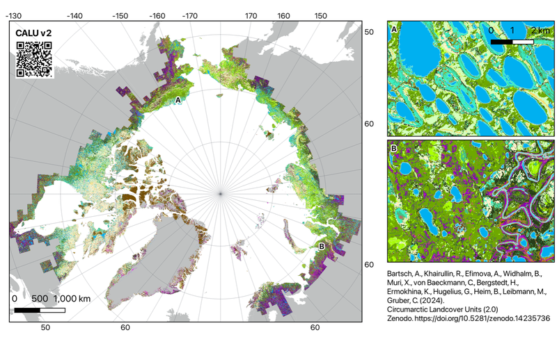
A new map of Arctic Land cover shows patterns of lakes, wetlands and vegetation types in unprecedented detail. Generated as part of ESA's Climate Change Initiative and derived from satellite data, the new circumarctic analysis maps tundra at 10-metre resolution.
The Permafrost_cci project team describe the new dataset in a study published in Hydrology and Earth System Sciences. The Circumarctic Land Cover Units (CALU) map significantly improves upon existing land cover maps, which have limited spatial resolution, thematic content and accuracy. It will be valuable for studying permafrost degradation, carbon cycling, and tundra ecosystems affected by rapid Arctic warming.
Key findings:
- Wetland and moist tundra types which are most relevant for methane emissions, cover 9% and 32% of the region respectively
- Wetter regions show higher land cover diversity than drier areas
- Wet, moist and dry landscape types co-occur close to each other north of the treeline
- 66% of the Arctic landscape is highly heterogeneous at 1 km scale, which is the scale typically used in land cover and permafrost global scale products


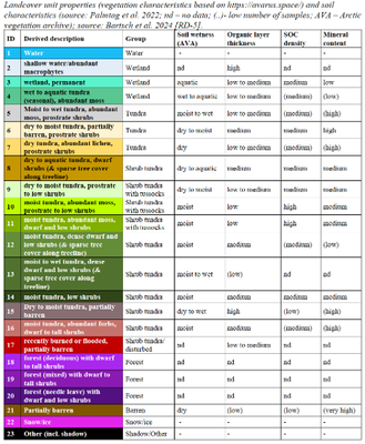
CALU was created by fusing Copernicus Sentinel-1 synthetic aperture radar data and Sentinel-2 multispectral satellite data from 2016 onwards, and documented with in-situ data. Land cover is classified into three types of wetland units and 14 terrestrial tundra units, covering barren areas and different types of shrub physiognomy and soil moisture gradients. The 9 years of satellite data was not sufficient for complete Arctic coverage due to frequent cloud cover. However, CALU v2.0 covers 99% of the Arctic tundra, excluding ice sheets. The latest release (November 2024) also includes additional regions addressing the needs of boreal carbon flux and biodiversity initiatives, for example Northern Scandinavia, southern Greenland and the Hudson Bay lowlands in Canada.
According to the study lead author, Annett Bartsch of Austrian company b.geos GmbH and science leader of Permafrost_cci project, "the new map enables advance for many aspects of permafrost research, including climate model parametrisation, upscaling in-situ measurement related to carbon stocks and fluxes, and assessment of disturbances. Use of the map is expected for a multitude of research activities related to ecology across the region."
Accessing the data
The data are available at: Bartsch, A., et al., Circumarctic landcover units (2.0), https://doi.org/10.5281/zenodo.14235736
Paper reference
Paper Reference: Bartsch, A., et al., Circumarctic land cover diversity considering wetness gradients, Hydrol. Earth Syst. Sci., 28, 2421–2481, https://doi.org/10.5194/hess-28-2421-2024, 2024

